
The Ultimate Pamir Highway Adventure: Crossing Kyrgyzstan and Tajikistan on the Roof of the World

Traveling the Pamir Highway is like driving through an epic painting where jagged peaks meet endless sky. This legendary road trip connects Tajikistan and Kyrgyzstan through some of Central Asia’s most jaw-dropping landscapes. As a traveler who recently completed this journey, I can tell you it’s not just a drive-it’s a life-changing adventure that will stay with you forever.
Table Of Content
- What Makes the Pamir Highway an Epic Adventure
- The Geographic Marvel of the Pamir Mountains
- Historical Significance and Cultural Crossroads
- Planning Your Pamir Highway Journey
- Best Time to Travel the Pamir Highway
- Essential Documentation and Permits
- Budget Planning and Real Costs
- Pamir Highway Routes and Itineraries
- The Classic Route: Dushanbe to Osh
- The Wakhan Valley Alternative
- Sample Itineraries Worth Considering
- Transportation and Practical Logistics
- Vehicle Options and Requirements
- Finding Tours, Guides and Travel Companions
- Accommodation Realities Along the Route
- Unmissable Experiences on the Pamir Highway
- Natural Wonders You Can’t Miss
- Cultural Encounters Along the Way
- Food and Cuisine Considerations
- Practical Tips for Pamir Highway Travelers
- Health and Safety Considerations
- Communication and Technology Tips
- Packing Essentials You’ll Thank Yourself For
- Frequently Asked Questions About the Pamir Highway
- Is it dangerous to travel the Pamir Highway?
- What permits do I need for the Pamir Highway?
- When is the best time to travel the Pamir Highway?
- How many days does it take to complete the Pamir Highway?
- What type of vehicle is needed for the Pamir Highway?
- How high is the Pamir Highway and will I get altitude sickness?
- Your Pamir Highway Adventure Awaits
What Makes the Pamir Highway an Epic Adventure
The Geographic Marvel of the Pamir Mountains
The Pamir Highway, officially designated as M41, stretches approximately 1,250 kilometers (800 miles) from Osh in Kyrgyzstan to points in Tajikistan. What makes this route truly special is its impressive altitude-it’s the second highest international highway in the world after the Karakoram Highway, reaching a breathtaking 4,655 meters (15,270 feet) at the Ak-Baital Pass.
The road winds through the Pamir Mountains, rightfully nicknamed the “Roof of the World.” Along your journey, you’ll witness:
- Towering peaks exceeding 7,000 meters
- Crystal-clear alpine lakes reflecting snow-capped mountains
- Deep valleys carved by ancient glaciers
- Wide-open high-altitude plateaus where the sky seems endless
- Dramatic border views into Afghanistan, China, and even distant Pakistan
Historical Significance and Cultural Crossroads
This highway isn’t just about natural beauty-it’s steeped in fascinating history. The Pamir Highway follows ancient Silk Road paths where traders once transported exotic goods between East and West. During the Soviet era, the road was fully constructed for military purposes, becoming a crucial link to remote mountain regions.
Today, the highway passes through diverse ethnic communities including:
- Pamiri people with their unique Ismaili Muslim traditions
- Kyrgyz nomadic communities maintaining traditional lifestyles
- Tajik villages with deep-rooted cultural practices
- Wakhi communities along the Afghan border
“The Pamir Highway represents the main supply route for Tajikistan’s Gorno-Badakhshan Autonomous Region (GBAO), which makes up 45% of Tajik territory but hosts just 3% of its population.”
Planning Your Pamir Highway Journey
Best Time to Travel the Pamir Highway
Timing is everything when planning this adventure. The extreme altitude means harsh winters and potential road closures.
- Peak Season (June-August): Warm days, minimal snow concerns, most facilities open
- Shoulder Seasons (May & September): Fewer travelers, cooler temperatures, possible early/late snow
- Winter (October-April): Not recommended unless you have extreme cold-weather experience and preparation
I traveled in mid-July and found perfect weather conditions-warm days around 70°F at lower elevations and refreshingly cool mountain air at higher points. However, a fellow traveler I met had attempted the route in early May and encountered a snowstorm that closed the highest passes for three days!
Essential Documentation and Permits
Before hitting the road, you’ll need several important documents:
- Valid passport with at least 6 months validity
- Tajikistan visa (can be obtained online through e-visa system)
- GBAO permit for the Gorno-Badakhshan Autonomous Region (can be requested with your visa application)
- Kyrgyzstan visa (many nationalities are exempt, check current requirements)
- International driver’s license if self-driving
- Vehicle insurance and documents if bringing your own vehicle
Budget Planning and Real Costs
The Pamir Highway can be done on various budgets depending on your travel style. Here’s a breakdown of typical costs based on my recent experience:
| Expense Category | Budget Option | Mid-Range Option | Comfort Option |
|---|---|---|---|
| Transportation | $30-50/day (shared taxi) | $150-200/day (shared 4×4) | $250-350/day (private 4×4 with driver) |
| Accommodation | $15-20/night (homestays) | $30-50/night (better homestays/guesthouses) | $60-100/night (best available hotels where possible) |
| Food | $10-15/day | $20-30/day | $40-50/day |
| Guide Services | Self-guided | $30-50/day (local guides at stops) | $80-120/day (dedicated guide throughout) |
| Total (7-day trip) | $400-600 | $1,400-1,900 | $2,700-3,600 |
Note: A typical 7-10 day tour package for a group of four sharing one vehicle costs around $1,300-1,800 USD total for the vehicle, driver, and fuel. This breaks down to about $325-450 per person, plus additional costs for accommodation ($15-20/night) and food.
Pamir Highway Routes and Itineraries
The Classic Route: Dushanbe to Osh
The most popular direction is starting in Dushanbe (Tajikistan) and finishing in Osh (Kyrgyzstan), though it can absolutely be done in reverse. The main route includes these key segments:
- Dushanbe to Kalai Khumb (350km): Beginning the journey with mountain passes and river views
- Kalai Khumb to Khorog (250km): Following the Afghanistan border along the Panj River
- Khorog to Murghab (310km): Climbing to high altitude plateaus
- Murghab to Karakul (135km): Reaching the highest elevations and alpine lakes
- Karakul to Osh (255km): Crossing into Kyrgyzstan and descending to lower elevations
The Wakhan Valley Alternative
Many travelers consider the Wakhan Valley detour absolutely essential to the Pamir Highway experience. This route follows the narrow corridor between Tajikistan and Afghanistan, offering:
- Stunning views across the Panj River into Afghanistan villages
- Ancient fortresses like Yamchun
- Traditional Wakhi culture and architecture
- Hot springs including the famous Bibi Fatima springs
- Dramatic mountain backdrops featuring peaks over 7,000 meters
My personal experience included this detour, and watching Afghan farmers tend their fields just across a narrow river was a profound moment-two worlds so close yet separated by more than just water.
Sample Itineraries Worth Considering
7-Day Express Journey:
- Day 1: Dushanbe to Kalai Khumb (350km)
- Day 2: Kalai Khumb to Khorog (250km)
- Day 3: Khorog rest day/explore town
- Day 4: Khorog to Murghab via direct route (310km)
- Day 5: Murghab area exploration
- Day 6: Murghab to Karakul (135km)
- Day 7: Karakul to Osh (255km)
10-Day Classic Journey with Wakhan:
- Day 1: Dushanbe to Kalai Khumb (350km)
- Day 2: Kalai Khumb to Khorog (250km)
- Day 3: Khorog rest day/exploration
- Day 4: Khorog to Ishkashim (120km)
- Day 5: Ishkashim to Langar via Wakhan Valley (110km)
- Day 6: Langar to Murghab (210km)
- Day 7: Murghab exploration day
- Day 8: Murghab to Karakul (135km)
- Day 9: Karakul rest day and lake activities
- Day 10: Karakul to Osh (255km)
Transportation and Practical Logistics
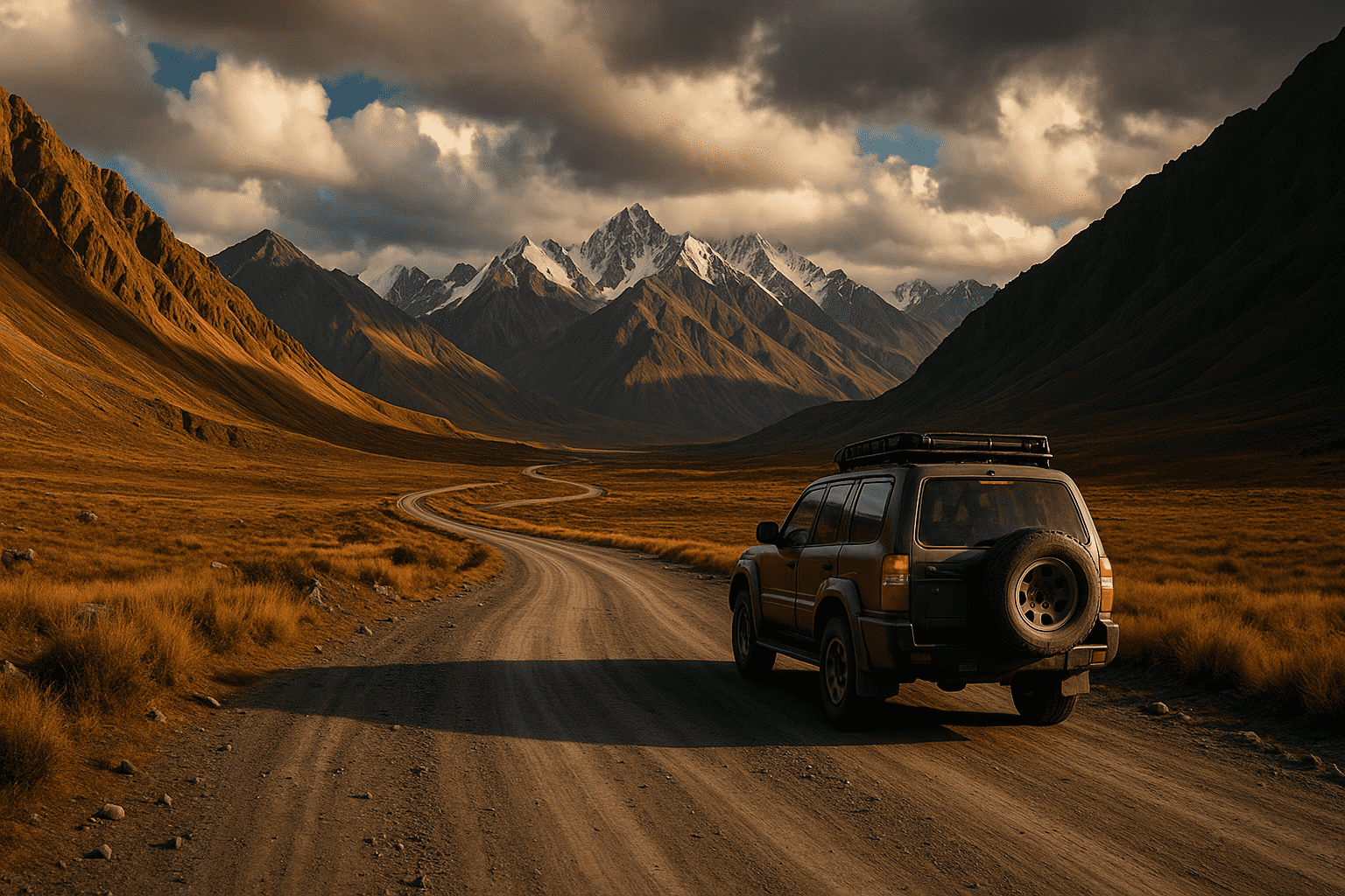
Vehicle Options and Requirements
The Pamir Highway demands respect-its rugged terrain, river crossings, and high passes require the right vehicle:
- 4×4 Vehicles: The only reliable option for the full route
- Motorcycles: Possible for experienced riders with off-road skills
- Bicycles: A challenging but rewarding option for the extremely fit
- Public Transport: Limited, unpredictable, but possible with patience
“This is rather tough travel where travelers overcome hundreds of kilometers of bad roads, harsh mountain climate, and spartan accommodation.”
When I traveled, our group shared a Toyota Land Cruiser with an experienced local driver. The benefit was immeasurable-he knew exactly where road conditions were worst, when river crossings were safest, and had connections in villages for emergency repairs if needed.
Finding Tours, Guides and Travel Companions
You have several options for organizing your trip:
- Pre-booked tours: Most convenient but priciest option ($1,300-1,800 for a vehicle)
- Arranging in Dushanbe/Osh: Lower prices but requires flexible time
- Finding travel companions: Check hostels, online forums, and Facebook groups
- Local fixers: Can arrange everything from permits to drivers
During my planning stage, I connected with two Hungarian travelers through a Facebook group. We split the cost of a 4×4 and driver, making the trip much more affordable while gaining great company for the journey.
Accommodation Realities Along the Route
Forget luxury hotels-the Pamir Highway offers more authentic sleeping experiences:
- Homestays: The primary option ($15-20 per person including breakfast/dinner)
- Guesthouses: Available in larger settlements like Khorog and Murghab
- Hotels: Very limited, only in main towns
- Camping: Possible and beautiful but prepare for extreme temperatures
Our most memorable stay was with a Pamiri family near Langar. The home featured traditional skylights, intricate woodwork, and the family served fresh apricots from their garden. Though the bathroom was a basic outhouse and electricity ran only 3 hours daily, the cultural exchange was priceless.
Unmissable Experiences on the Pamir Highway
Natural Wonders You Can’t Miss
The Pamir Highway offers natural spectacles that will leave you speechless:
- Karakul Lake: A massive high-altitude lake with stunning reflections
- Ak-Baital Pass: The highway’s highest point at 4,655 meters
- Wakhan Corridor Views: Where four mountain ranges converge
- Bartang Valley: Dramatic gorges and traditional villages
- Bulunkul Lake: Often frozen even in summer
Cultural Encounters Along the Way
The people make this journey truly special:
- Pamiri Hospitality: Experience traditional homes with five pillars representing Ali, Muhammad, Fatima, Hassan, and Hussein
- Kyrgyz Yurt Stays: Opportunity to stay with nomadic families
- Local Festivals: If timing aligns, experience traditional music and dance
- Handicraft Workshops: See traditional weaving and felt-making
- Ancient Petroglyphs: Discover rock art dating back thousands of years
Food and Cuisine Considerations
Food along the Pamir Highway can be challenging but interesting:
- Breakfast: Usually bread, jam, eggs, and tea
- Lunch: Often simple roadside cafes serving soup and bread
- Dinner: Homestays typically offer hearty stews, plov (rice dish), or simple meat dishes
- Vegetarian Options: Limited but improving-communicate needs clearly
- Special Treats: Fresh apricots, mulberries, and walnuts in season
One key tip from personal experience: bring protein bars, nuts, and comfort snacks. When we encountered a landslide delay of 6 hours, these supplementary foods were crucial.
Practical Tips for Pamir Highway Travelers
Health and Safety Considerations
The Pamir Highway presents specific challenges:
- Altitude Sickness: A serious concern-ascend gradually and consider medications
- Water Safety: Bring purification tablets or filters
- First Aid: Pack a comprehensive kit as medical facilities are scarce
- Travel Insurance: Essential, ensure it covers high-altitude activities
- Border Areas: Some regions require special permissions-respect restrictions
I experienced mild altitude symptoms at Murghab (3,650m) despite feeling fine earlier. Taking a rest day here helped immensely before continuing to higher passes.
Communication and Technology Tips
Staying connected presents challenges:
- SIM Cards: Purchase in Dushanbe or Osh before departing
- Coverage: Sporadic-expect days without service
- Power: Bring portable chargers/solar options
- Maps: Download offline maps and consider a paper backup
- Language: Learn basic Russian or Tajik phrases-English is limited
Packing Essentials You’ll Thank Yourself For
Based on my journey, these items proved invaluable:
- Layered Clothing: Temperatures can swing 40°F in a day
- Sun Protection: The high altitude makes sun extremely intense
- Medications: Including altitude sickness prevention
- Cash: ATMs are rare-bring USD in smaller denominations
- Gifts: Small items to thank homestay hosts
- Patience: The most important thing to pack!
Frequently Asked Questions About the Pamir Highway
Is it dangerous to travel the Pamir Highway?
With proper preparation, the Pamir Highway isn’t dangerous, but it does present challenges. Road conditions can deteriorate quickly with weather, altitude sickness is a real concern above 3,000 meters, and medical facilities are limited. However, tourists travel the route regularly with few incidents beyond vehicle breakdowns and minor health issues.
What permits do I need for the Pamir Highway?
You’ll need a Tajikistan visa and a GBAO permit (Gorno-Badakhshan Autonomous Oblast) to travel most of the Pamir Highway. These can be obtained together through Tajikistan’s e-visa system. Kyrgyzstan offers visa-free entry for many nationalities.
When is the best time to travel the Pamir Highway?
June through September offers the most reliable weather conditions. July and August are peak season with warmer temperatures even at high altitudes. May and early October are possible but come with increased risk of snow at high passes.
How many days does it take to complete the Pamir Highway?
A minimum of 5-7 days is needed to simply drive the route, but 10-14 days allows for a more enjoyable pace with time for side trips, rest days (important for acclimatization), and cultural experiences.
What type of vehicle is needed for the Pamir Highway?
A 4×4 vehicle with good clearance is essential for the entire route. Parts of the highway are paved, but many sections feature rough gravel, washboard surfaces, and occasional river crossings that require capable vehicles.
How high is the Pamir Highway and will I get altitude sickness?
The highest point on the Pamir Highway is the Ak-Baital Pass at 4,655 meters (15,270 feet). Altitude sickness is a legitimate concern. Plan your itinerary to ascend gradually, stay hydrated, consider preventative medications, and include rest days for acclimatization.
Your Pamir Highway Adventure Awaits
The Pamir Highway offers more than just stunning views-it provides perspective. Driving along ancient trade routes, witnessing traditional life continuing as it has for centuries, and experiencing the raw beauty of untamed mountains connects you to something bigger than yourself.
If you’re seeking an adventure that combines natural wonder, cultural discovery, and personal challenge, the Pamir Highway delivers on all fronts. The journey isn’t always comfortable, but the best adventures rarely are.
Are you ready to travel one of the world’s most epic roads? Start planning your Pamir Highway adventure today-gather your documents, choose your season, find your companions, and prepare for an unforgettable journey across the Roof of the World. The mountains are waiting.


